What does the future look like for Georgia, and how do we prepare for it today?
It’s a question more leaders across the state are beginning to ask. From unexpected heat in February to stronger storms reaching farther inland, the signals are becoming harder to ignore. While the changes can feel unpredictable, the path forward does not have to be.
New tools like the Drawdown Georgia Climate Outlook Maps are helping turn uncertainty into insight. They give communities, businesses, and decision-makers a clearer way to plan for what’s ahead.
In our latest Georgia Climate Digest video interview, host Eriqah Vincent sits down with Dr. Marshall Shepherd, an internationally recognized climate scientist at the University of Georgia and an early contributor to Drawdown Georgia, to explore how climate conditions are evolving across the state and how tools like the Climate Outlook Maps can support smarter, more resilient planning.
Chapters:
00:53 - Understanding the Difference Between Weather and Climate
04:57 - Overview of the Climate Impacts Already Affecting Georgia
10:46 - Understanding Climate Projections in Georgia
21:01 - What Makes the Climate Outlook Maps a Valuable Resource for Georgians
23:49 - What Users Should Keep in Mind When Reviewing the Climate Outlook Maps
26:21 - What Climate Resilience Looks Like in Georgia
29:21 - How to Center Equity in Resilience Planning
35:11 - What’s Giving Marshall Shepherd Hope Around Climate in Georgia
Watch the video above to hear their full conversation, or keep reading to learn about what a changing climate looks like in our state, and how the Climate Outlook Maps can help Georgia policymakers, business leaders, and community leaders plan for the future.
What is the difference between climate and weather, and why does it matter?
One of the most helpful ways Dr. Shepherd explains climate is through a simple analogy:
Weather is your mood. Climate is your personality.
Day-to-day weather changes, like a cold snap or a warm week, do not define long-term trends. Climate reflects patterns over time, including averages, extremes, and how often those extremes occur.
That distinction matters. Georgia has always experienced swings in weather, but what we are seeing now reflects both natural variability and additional warming influences that are amplifying those patterns.
As Dr. Shepherd explains, it is not an either-or conversation. It is both. And that “both” is what communities need to plan for.
What changes are already happening across Georgia?
Across the state, long-term shifts are already showing up in ways that affect daily life, local economies, and public health.
Dr. Shepherd highlights several key trends:
-
Rising nighttime temperatures, which can increase health risks, especially in urban areas
-
Heavier rainfall events that lead to more frequent flooding
-
More intense drought conditions, particularly in agricultural regions
-
Stronger hurricanes reaching farther inland
-
Shifts in growing seasons and ecosystems that affect agriculture, pollen cycles, and wildlife
These changes are not theoretical. They are already influencing everything from crop yields to infrastructure performance.
They also do not happen in isolation. Dr. Shepherd points to compound events, where one disruption triggers another. For example, a storm can cause power outages, which can lead to water system failures or longer-term economic impacts.
Why are the Climate Outlook Maps such an important planning tool?
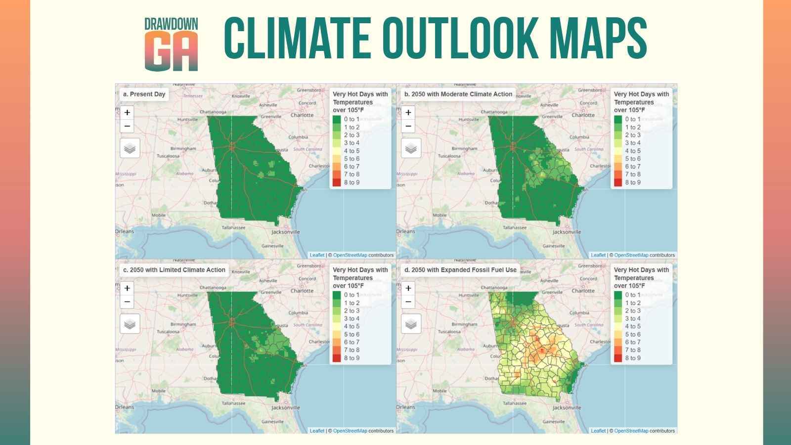
The Drawdown Georgia Climate Outlook Maps are designed to show a range of possible futures. Instead of offering a single prediction, they present different scenarios based on how greenhouse gas emissions may change over time.
Users can explore how conditions like temperature, precipitation, growing seasons, and extreme weather could evolve by 2050.
According to Dr. Shepherd, this range-based approach is exactly what makes the maps valuable. “Any good business practice or policymaker is not going to make decisions based on a single outcome,” he explained. “You need to understand the range of possibilities.”
The Climate Outlook Maps can support:
-
Local governments planning infrastructure and land use
-
Businesses evaluating long-term risks and opportunities
-
Community leaders preparing for changing conditions
-
Researchers and planners analyzing trends across regions
They also translate complex climate data into formats that are easier to understand and apply. That makes them a practical tool for real-world decisions.
Why is it important to plan for 2050 while also focusing on today?
While the maps focus on 2050, Dr. Shepherd emphasizes an important point. Climate impacts are already here.
From Hurricane Michael to Hurricane Helene, from flooding in Atlanta to ongoing drought conditions, Georgia communities are already experiencing the types of events the maps are designed to help anticipate.
Planning for the future and acting in the present must happen together.
The Climate Outlook Maps provide a longer-term lens. Current conditions highlight the need to strengthen resilience now.
What does climate resilience look like in different parts of Georgia?
Resilience looks different depending on where you are in the state.
In coastal communities, it can mean preparing for sea level rise and tidal flooding.
In agricultural regions, it may involve drought-resistant crops and more durable infrastructure.
In cities, it often includes upgrading stormwater systems and addressing urban heat.
>>Learn more about the resiliency efforts already underway on Georgia’s 100 miles of coastline.
Dr. Shepherd also highlights the value of nature-based solutions. Wetlands, tree cover, and green infrastructure can reduce risk while improving community well-being.
At the statewide level, efforts such as the Georgia Statewide Resilience Assessment are helping to align these strategies. The assessment was commissioned by the Pew Charitable Trusts and developed by the University of Georgia’s Institute for Resilient Infrastructure Systems, and it provides guidance for strengthening resilience across sectors.
How should communities think about equity when planning for resilience?
Resilience planning must account for differences in how communities experience and recover from extreme events.
While many communities face similar risks, not all have the same capacity to respond or recover.
Effective planning includes:
-
Engaging communities directly in decision-making
-
Building local knowledge and awareness
-
Investing in resources where they are needed most
-
Supporting grassroots leadership and partnerships
In Georgia, this work is already taking shape through local sustainability efforts, community organizations, and cross-sector collaboration.
What is giving leaders hope about Georgia’s climate future?
Despite the challenges, Dr. Shepherd remains optimistic about Georgia’s path forward.
He points to the state’s strong network of universities, businesses, nonprofits, and community leaders who are working together to advance climate solutions. He also highlights Drawdown Georgia as an example of how research, collaboration, and practical tools can come together to support meaningful progress.
Georgia is building a model that other states can learn from.
How can you explore the Climate Outlook Maps and start planning?
The Drawdown Georgia Climate Outlook Maps are designed to help turn insight into action. They offer a clear, accessible way to understand what may lie ahead and how to prepare.
Whether you are shaping policy, managing operations, or supporting your community, these maps can help you plan with greater confidence.